|
Cockley Beck, Duddon Valley, Seathwaite Tarn, Great Carrs, Grey Friar, Cumbria. Tue 05 June 2007 |
|
|
|
|
|
A weather forecast of steady high pressure meant a very good chance of a sunny walk. I drove through Ambleside and on to Skelwith Bridge with hardly any traffic on the road. I was glad of the quiet roads as I drove on to Little Langdale where the road is only one car wide with few passing places. As I started to drove up the steep Wrynose pass I saw a cyclist way ahead of me. He was on a lightweight bike and making good time as I passed him. Over the top of the pass I was surprised to see several cars parked in the small parking area. After descending into Wrynose Bottom there were still cars parked by the road, and all before 8am. It was sunny and warm when I arrived at Cockley Beck. There was a good view up the steep road up Hardknott pass and before long the cyclist I’d seen on Wrynose turned up and then started up Hardknott. I left my car and set off walking along the road down the Duddon Valley. |
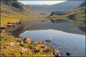
 The Duddon Valley. |
|
|
It was a very pleasant wander along the remote country lane. At the Dale Head buildings there were some bikes propped up against the wall with chairs and bottles strewn about the place. Even a part consumed bottle of expensive whisky was sat on the grass, but nobody was about. It was the classic scene of the aftermath of a party so presumably the partygoers were somewhere in the building, sleeping it off. I pressed on and after passing the Hinning House buildings, owned by Wigan Borough, I left the road at a path heading up into the pine woods. I emerged into open ground at ‘The Close’ and started to climb through cotton grass then newly growing ferns. The path was indistinct but I found it again at the wall higher up. Crossing Foss How I had a wonderful view back down the lush green Duddon Valley. Up ahead was the dam of Seathwaite Tarn. |
|
I soon reached it and continued following the path along the left side of the tarn. Eventually I left the tarn and came to the Seathwaite Copper Mines. None of the entrances were open but plenty of spoil heaps and buildings showed where they had been. Fortunately the old track to the higher mines was still passable and made a welcome change to the rough path earlier. |
|
|
|
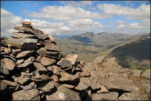
I started to climb Tarn Head Beck and stopped for a while to see if there was any sign of the path up to Levers Haws that is shown on the map. I could see no sign of it whatsoever and I’m not surprised looking at the steep scree that it is supposed to follow. I wonder where the Ordnance Survey gets these routes from? At the high end of the valley are several springs and this is the area I camped at in March 2007, but then the weather was bad, with thick cloud and rain. I was much luckier now with clear views and just a few fluffy clouds in the sky. I climbed to Great Carrs then on to the air crash memorial on Little Carrs. |
|
I looked down into Tilberthwaite to see the remains of the fuselage of the Halifax bomber LL505 which crashed in October 1944. The memorial is the crash site but the wreckage was pushed over the cliff edge into the valley below. I turned west and headed for Grey Friar. The weather remained good and the views were wonderful all around. The short climb up to the summit is rewarded with a large area of flat ground and fantastic view all around especially to the north west where the panorama included Sca Fell, Mickledore, Scafell Pike, Bow Fell etc. There was no sign of the descent path to Cockley Beck so I just took my time and wandered down the easy series of grass slopes and rocky outcrops. Near the bottom I joined to old track which was easy to follow and almost took my all the way back to the car. |
|