|
Irton Pike, Whin Rigg, Illgill Head, Burnmoor Tarn, Miterdale, Cumbria. Wed 30 May 2007 |
|
|
|
|
|
I had a fairly clear drive to Miterdale near Eskdale Green with hardly any traffic on the road. I arrived at the small car park just before 8am and was soon on my way heading west through Miterdale Forest. I followed the forest road and occasionally saw paths heading off in various directions, but no path signs, so I didn’t know where they went. Eventually the pines thinned a bit and I was able to see down on to the Bowerhouse Inn. After a short stint back in the forest I emerged onto a track and then the road. A short way ahead I came to a small car park in an old quarry then the main path to Irton Pike. |
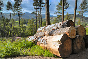 In Miterdale forrest. |
|
|
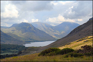
A rough track took me steadily up to a gate where I came to open fell. The continuing path was fairly indistinct but the way ahead was in clear view so I had no problems finding my way. It was a very nice walk and as I got higher the views improved and I had a new view of Wast Water as this was my first time up this path. I’d seen some low cloud earlier but now there were large white billowing clouds in a beautiful blue sky. I seemed to pass over Irton Fell in no time and soon found myself looking down the impressive gulley of Greathall Gill, the spot where I left the fell last week in bad visibility. There was a bit of wind blowing so I descended a short way into the gully to get shelter and stopped for a coffee from my flask. |
|
I continued up Whin Rigg to the summit to be treated with some superb views of the surrounding mountains. I found shelter from the wind behind some rocks and decided to stop for lunch. The sun came and went but the cloudscapes were very impressive. Continuing to Illgill Head I passed between the two tarns that I briefly saw though the mist last week. They seemed smaller now that I could see their full extent. |
|
|
|
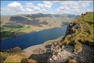
I headed for the edge of the top of the screes above Wast Water and walked along that route most of the way to Illgill Head. I’d never had good enough weather to do this before so got a new experience of the exhilarating views. At the Illgill summit cairn I had a look round for any evidence of the Ordnance Survey trig point that is shown on my 25K map, but couldn’t find any sign. I continued along the main path for a while then took a sharp right turn and headed down towards Burnmoor Tarn. The descent is interesting as it is a mix of steep grass and occasional flat platforms that would make good campsites. Sadly there is no water other than the tarn a long way below. I reached the main path and decided to stay on the high path above Miterdale, heading down the valley. |
|
It was a fairly level path all the way to Tongue Moor where I climbed a little to the main route down to Miterdale Head. At the Bakerstead building there seemed to have been a bit of vandalism as some windows were broken. The map shows it as an Outward Bound Centre but I’ve never seen anyone around when I’ve passed. When I got back to the car park there were a few more cars about. There was a woman by her car who turned out to be a teacher at the little school at the end of the road. I think its St Bega’s primary school. She had just returned from Burnmoor Tarn where some students had been camping. |
|