|
Sunkenkirk stone circle, Swinside, Black Combe, White Combe, Millom, Cumbria. Wed 21 Mar 2007 |
|
|
|
|
|
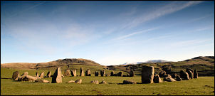
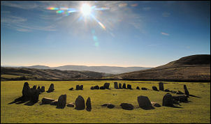
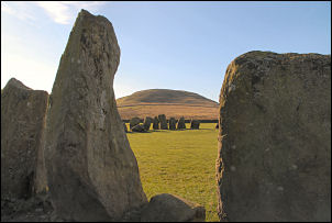
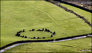
Many years ago I had a walk up to the magnificent stone circle at Swinside near Millom, Cumbria. I thought it was about time to re-visit the site and also take a look over the Black Combe and White Combe areas. I was blessed with a wonderfully sunny morning as I drove to Cumbria. It was clear and cold and the car’s outside temperature sensor showed -1dec C most of the way. Swinside Farm is about a mile up a private track. I left the main A595 road and took the narrow lane which is signposted ‘Fell Road’. Near a gate I found a wide verge and was able to leave the car and set off for the circle. It is a while before it comes into view but when it does it is worth the effort. The circle comprises 55 of the original 60 stones formed into a 90ft circle |
|
|
|
|
|
|
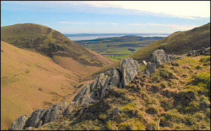
The map names it Sunkenkirk. It is on private land but when I got there the gate had an open catch on it. I reckoned that it would be OK to go into the field and have a look, so I did. With a long walk ahead I didn’t linger too long as I wanted to get up Raven Crag and look what they looked like from a higher altitude. The path goes through the Farm Yard but I couldn’t see a way marker. A man was up on some scaffolding doing some work on a building so I asked him the way. A farm track runs round the base of Raven Crag so I followed it part way then cut off west to take a direct route up the fell. It was so nice to walk up firm dry grass for a change and when I got to the first part of the climb I had a rest stop by a small cairn. The way on along the ridge was blocked by a stone wall. I could se a crossing point where others had been and headed for it. A couple of ‘throughs’ enabled me to get over without displacing any stones but this is a case for fitting a proper crossing point. |
|
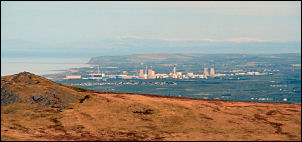
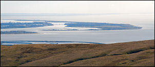
I had wonderful views down onto the stone circle and also across to Sellafield nuclear power recycling plant to the NW; it was an interesting contrast; looking down at prehistoric man’s need to worship and modern mans need for power. |
|
|
|
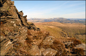
Eventually the summit of Black Combe appeared in the distance but I decided to find a sheltered spot along the ridge of Blackcombe Screes first. The idea was to sit down and enjoy a leisurely lunch with wonderful views. I found the ideal spot with shelter from the cold breeze and something of a sun trap. |
|
It was wonderful. I enjoyed the views, my sandwiches and coffee and stayed much longer that normal. I was so well hidden away that I heard people chatting as they walked by and didn’t even notice me. I set off and headed for the summit trig point where a group of walkers were sat in the cold breeze eating their sandwiches. I didn’t tell them about my hidey hole. I started down heading east across gently sloping grass. The gradient steepened as I approached a flat area called Eller Peatpot. Whoever gave it that name should be given an award. |
|
|
|
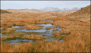
The area was wet and boggy but it was all frozen solid. Another steep descent took me to Blackcombe Beck where I picked up a nice path which I followed to Horse Back and down to Whitecombe Beck. Part way down I noticed a piece of aluminium airplane wreckage, but it was small and on its own. I crossed a wooden bridge and up a very well defined path which must have been a substantial track in years past. |
|
When I got to the top of Whitcombe Moss the way ahead wasn’t obvious. I wanted to descend via Gray Stones but all I could see was the flat summit plateau. I took a guess at the direction and eventually found myself descending the correct mountain. There was no path at first but one soon became apparent. However, I didn’t want to descent too far as I was heading for Knott Hill on the other side of the mountain. I left the path and skirted round until I could see my objective. Another steep descent took me to a stone wall and more pieces of wreckage. There is no footpath across the valley bottom so I picked the best way I could and by Knott Hill to the farm track. From then it was an easy and pleasant walk back to the car. |
|
|
|
|