|
Miterdale, Illgill Head, Burnmoor Tarn, Cumbria. Thu 08 Mar 2007 |
|
|
|
|
|
For today’s walk I am indebted to Keith Whiteside for pointing me in the direction of one of Lakeland’s hidden gems, Miterdale. Between Eskdale and Wasdale is this fine valley that has a delightful car park, no thorough road and a valley that gets better the higher you walk up it. From Eskdale Green a narrow unmarked road goes up by the river Mite. It is adopted but looks more like someone’s private drive. At the end of the narrow hedged section it opens out into the main valley and a very nice grass car park area by the bridge. I was surprised to see another car arrive just after I did but the man was just there to walk his dog. I set off along the farm track, which was now a dirt track and not tarmac. Low Place farm was nice and tidy in the farmyard but very muddy at the rear where the path goes. |
|
|
|
At the river is a footbridge but the map shows a path on either side of the river. I wanted to go up the left side of the valley but there was a rope stretched across the path so I reluctantly crossed the bridge and headed up an even muddier track. I waded through cow muck then just plain mud until I caught sight of Bakerstead which is shown on the map as an Outdoor Pursuits Centre. The way I wanted to go was by the building so I had to get across the river again. When I got down to the bank there was only a ford and it was too wide to hop across so I took boots and socks off and waded. When I reached the building I noticed a makeshift footbridge of logs which isn’t marked on the map. Nobody was about so I continued past the ruins of Miterdale Head and up onto the moor. Once clear of the Pine trees the views began to open out and it was drier underfoot. |
|
|
|
|
My first objective was Illgill Head which was way up to the left. I couldn’t see the summit or much of the climb because of cloud but the slope didn’t seem too bad. I climbed steeply down to Robin Gill, stepped over and began the climb up Little Grain Gill. The cloud began to clear a bit and the views improved all the time. There was hardly any wind so I picked a nice rock about a third the way up to stop for a sit down and drink of coffee. There was no path but no problems continuing the climb. As I came towards the summit the gradient eased and I was able to see a little more of the ridge. I passed some rock outcrops but the summit cairn was on a large flat area. Enough clouds rolled away to reveal Wastwater below. I followed the main path for a while then left it to descend a little to the top edge of ‘The Screes’ and to find shelter from the wind before stopping to eat my sandwiches. |
|
|
|
The views came and went as the clouds rolled by but I got a nice view across to Yewbarrow but Great Gable was in cloud the whole time. I rejoined the main path but soon left it to descend directly down towards Burnmoor Tarn and a path that I hoped would take me back to Miterdale. |
|
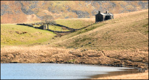
Burnmoor Lodge above the southern shore of the tarn looked very isolated and forlorn. Nobody else was to see anywhere. Eventually I came across a path but it was too high so I continued down to the wide, flat and boggy area before the start of the valley. I soon reached the head of the valley and was surprised to see a valley head surrounded by vertical cliffs, though not too high, and a series of waterfalls tumbling down to start the river. |
|
|
|
A path took me down into the sheltered valley bottom with flat grassed areas by the river. The path started off narrow and dry but further down some stretches were rather wet. It was an easy and pleasant walk all the way back down to Miterdale Head. I decided to return to Low Place on the opposite bank this time so crossed the river by the log footbridge. It was well made with plenty of rope lashings and wire mesh fixed to aid grip. I had another look at Bakerstead before following the path across fields back to the lower footbridge. It was wet in places but not as muddy as the path I’d come up earlier. At the farm there was still nobody about so I continued along the track and back to the car. |
|
|
|