|
Torver, Tranearth, Walna Scar Road, Walna Scar, White Pike, Caw, Cumbria. Wed 07 Mar 2007 |
|
|
|
|
|
To the SW of Coniston are the Dunnerdale Fells, an area I’ve not visited. I drove up the narrow lane off the A593 near Torver and followed it to the car park at the summit. It wasn’t an ideal spot to start my walk so I continued round to Water Yeat Bridge where I parked by a very wet gate entrance to the plantation. I set off under overcast skies along the forestry road at the base of ‘The Knott’. I followed it round to Appletree Worth Beck and on to a point where it crossed the river. The track continued diagonally up the hillside and I followed it. Unfortunately I should have followed a path that leaves the bridge. I stayed on the track and followed another back to pick up the path higher up. After a short walk through dense woodland I emerged back onto the narrow lane I’d driven up earlier. The map calls it Hummer Lane. |
|
|
|
I followed it back down to the main A593 and on into Torver. The last bit of the road follows the line of the old railway to Coniston and it is possible to see the route crossing the field on the right. Just before the bridge over Torver Beck is a narrow lane to the left. I took it and headed up High Torver Park. The map shows a camping area but I saw no sign of one. I camped here many years ago when I once cycled from home, camped overnight, and then cycled home again. The lane then becomes an un-surfaced track and I followed it to the Climbing Hut on the approach to the old quarries. The area is known as Tranearth and many years ago I used to come here with members of Chorley Sub Aqua Club to dive in the flooded quarry higher up the fell. I even used to drive up the rough track in a borrowed car! The quarries look like slate quarries and higher up is one deep quarry which is partially flooded and the one just mentioned. |
|
|
|
|
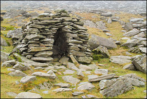
After leaving that behind I was on the open fell and heading for the Walna Scar path. There was still low cloud so the higher fells were obscured. After reaching what is known as the main Walna Scar Road, though I doubt any vehicles would ever get up it nowadays, I came to the stone bridge over Torver Beck. For some inexplicable reason there were iron railings along both parapets. There is no long drop or any danger that I can think of by crossing over the bridge. The railings seem totally unnecessary. Do I detect the hand of Health & Safety here? Before the summit of the pass is an interesting stone shelter of the beehive type of construction. I’ve seen other similar ones below Nan Bield pass, by Small Water. By now I was in mist and at the summit the full force of the westerly wind hit me. I turned SW and along the edge of Walna Scar. |
|
|
|
There is a steep drop off on the east side and I descended it a short way to get shelter so I could eat my sandwiches. A few gaps opened in the mist and I was briefly able to see below. I continued, following a path in the mist. I came to White Pike which is just a little lower than the summit of White Maiden which I’d walked past without seeing it. A fairly steep but not difficult descent took me to Caw Moss where I could see at last and had a reasonable view of the fells ahead and up to Caw which was my next objective. |
|
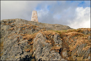
I had to be careful crossing some of the boggy patches as I’d managed to keep my feet fairly dry up to now and wanted to keep it that way. As I approached Caw the route up wasn’t that obvious as I lost sight of the summit. I almost finished up on a minor summit to the south and had to retrace my steps to get to the top. There was a nice trig point and good views. I looked down to try and decide the best route. The first part was fairly obvious but as I got lower I kept more to the left and drier ground. A final steep slope took me to the River Lickle and a stone footbridge where I joined the forestry road. After a short walk I was back at the car. |
|
|
|
|