|
Shap, Hardendale, Oddendale, Black Dub monument, Crosby Ravensworth, Cumbria. Wed 01 Nov 2006 |
||
|
|
||
|
I had a dark but clear drive up the M6 motorway to the Shap exit no. 39. Clear of traffic and clear weather. Instead of turning left towards Shap I turned right along the minor road to Hardendale. It was just below zero and parts of the road were covered in ice, probably the first frost of this winter. After crossing the Quarry access road I parked off the road, which was easy as it’s unfenced. I left the car under a clear cold sky and soon I was in sunshine, but no warmth yet. I retreated along the road for a short way to Nab House then turned left (east) along the green path. This is also the ‘Coast to Coast’ route. |
 Sunny morning at Nab House |
|
|
|
Over a grassy rise with limestone clints I came to the main access to the Hardendale Quarry. It was quite busy with huge lorries coming too and fro. A track took me to Oddendale and the tarmac road. The clear sunny weather looked like it would hold and in front I could see a wonderful panorama of the low fells away in the distance. As I passed the hamlet of Oddendale and its trees the Howgill Fells appeared in the distance. |
|
|
|
||
|
I’d planned to walk via Wicker Street cairn but up ahead I could see the tantalising outline of Coalpit Hill with its trig point and large cairn. I decided to make the detour which turned out to be easier than expected. There was a faint hint of a path which got me to the summit where I was able to get a good 360 deg view. The M6 motorway was in view from junction 39 right down to Tebay and beyond. |
|
|
|
|
To regain my route I set off across the
heather following a compass bearing until I came to the line of the
Roman Road. I crossed over then headed down into the dip towards Black
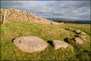
Dub and the monument that is shown on the map. It came in to view and
has certainly not been put there because of its visibility. It marks an
interesting spot that has importance in British history. The inscription
is difficult to read and covered in lichens but is referred to in
Wainwright’s Coast to Coast book. He says it reads:
It marks the place where Charles II rested with his army in 1651 when marching from Scotland following his coronation in Scone on 1st. January 1651. |
|
|
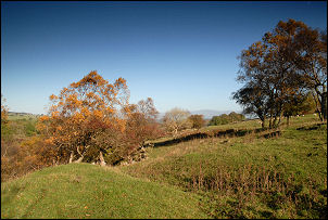
The spring nearby is clear and issued straight out of the ground, an ideal place to rest an army. Also next to the monument was a concrete slab which looked like it could have been the base of a shooting hut. A collapsed timber frame and corrugated roof was nearby, possibly indicating that it had been blown off the base by strong winds. Continuing east I came to a wall and rejoined the ‘Coast to Coast’ route. I didn’t stay with it long as I wanted to explore the valley of Livennet Beck. Over the wall to the left was another spring issuing straight from the ground. This one is called Kings Well and I suppose it could also have been the spot where King Charles stayed. Walking down the valley I came to a green track which I followed, passing limestone out crops and trees. The trees below were in their autumn colours and the sunshine certainly helped to show them at their best. |
||
|
|
|
|
|
A footbridge and ford crossed the river further down then I followed limestone walls into the village of Crosby Ravensworth. It was strung out along the road and was very quiet. I didn’t see anybody. |
|
|
|
|
||
|
|
|
|
|
I turned left into Harberwain Lane, over the river and up the hill. When the road turned sharp right I continued straight on and over the fields to Iron Hill and a couple of small but nice stone circles. When I reached the road the layout didn’t match the map. It turned out that the road had been altered after the map edition to allow more land fort the quarry workings. Skirting the north side of the quarry I reached the road and my car. |
||