|
Buzzard Knott, Skiddaw, Lonscale Fell, Skiddaw House Farm, Cumbria. Thu 07 Sep 2006 |
|
|
|
|
|
I Drove along the A591 north of Keswick and took the right turn before Bassenthwaite towards Uldale. I left the car at the parking area near Peter House Farm and walked back along the road to the main path up Ullock Pike. I followed the main path for a while but instead of going up the main ridge I continued along the green track up Southerndale. Although good weather was forecast I could only see low cloud ahead. It was pleasant walking and I followed the track until it fizzled out. It was interesting looking down into Barkbeth Gill to see a track running up the valley side, crossing the gill and continuing diagonally up to Broad End. |
|
|
|
I headed up to a saddle at Great Knott and continued up the ridge of Buzzard Knott. There was a faint hint of a trail and by keeping to it was able to climb through the rocky areas without too much trouble. I was soon in cloud which is a shame as I bet the views on the climb are very good. My objective was to investigate a flat area on the ridge which I’d seen from Ullock Pike. Eventually the gradient eased and I was on the shelf. It was surprisingly large and would make a good place to pitch a tent. But it was at 700m, quite exposed and there was no water. So water would mean a long carry up from the beck below. The remains of an old stone shelter was cut into the west side of the ridge and I suppose this is where shepherds would have stayed. I headed up into the cloudy murk of Randel Crag into fairly scrambly going. The flat stones were very slippery in the mist and it was far from straightforward to climb the last 200m to the summit of Skiddaw. I’d judged the ascent line OK and found I could just see the trig point and view marker when I got to the top. |
|
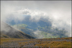
I continued south on the main path and soon started to meet people coming up. As I descended I started to catch the occasional glimpse of the valleys below. Then Derwent Water came in to view then vanished again. |
|
|
|
|
|
|
At the gate at Jenkin Hill I turned left to leave the main path and follow the fence line towards Lonscale Fell. A farmer approached on his quad bike and two dogs running in front. Without stopping he passed and vanished up the hill. |
|
I stopped for lunch at the same stone wind shelter I’d used on last week’s walk. The weather was now quite nice and looking back the full summit of Skiddaw was visible. I paused on Lonscale Fell and looked over the edge and down to Glenderaterra Beck and the magnificent views of Blencathra and surrounding area. |
|
|
|
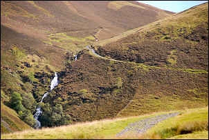
I headed NW to the fence line then took a very steep line down to a flat area just before the start of the Burnt Horse Ridge. This was a very fine path with more wonderful views. The descent took me down to the main path, which is also the Cumbria Way, where I turned left towards Skiddaw House. When I arrived at the house nobody was in residence, but a man was sat at the front having his lunch. We chatted for a while then I set off along the track back to Whitewater Dash falls. |
|
As I descended people on mountain bikes began to appear. The first man was still able to keep pedalling upwards, just. Further on a middle aged couple were standing by their bikes and I doubt they’d be getting on again until the top of the climb. Then I came to the farm access road, turned left and back to the car. |
|