|
Murthwaite, Harter Fell, Knott, Grere Fell, Adamthwaite, Cumbria. Wed 16 Aug 2006 |
|
|
I arrived at the small car park adjacent to Rawthey Bridge on the A683 Sedbergh – Kirkby Stephen road about 7:15am. Shortly after arriving I watched the 564 bus pass on its way to Kendal. It was no surprise to see that it was empty of passengers. The last time I used the service there was only me and one other person on it. I followed the path through dew sodden fields on the north side of the river and then turned NE up through the woods to Murthwaite. As I left the trees a deer bounded across the field. The views back down the Rawthey valley were quite picturesque but the distant haze prevented really nice views. |
|
|
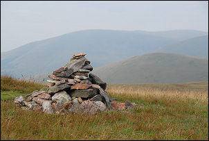
Murthwaite is a working farm but when I passed there was nobody about. I headed north towards Harter Fell but the track soon became indistinct, then improved again as another farm track joined it from the right. I didn’t stay with the official track for long as I cut up to the right to follow an old green track diagonally up the side of Harter Fell. After a while I left this and took a steep direct route up the west side. Once the gradient had eased I was able to wander easily towards the summit cairn in the distance. Looking back I could clearly see the farmstead of Adamthwaite, which Wainwright’s Howgill Fells book describes as attractive. Maybe it was when he saw it but now it has a look of neglect with many new outbuildings which weren’t there when Wainwright made the sketch for his book. Near the Harter Fell cairn was the remains of a large bonfire and judging by the rusting hoops of wire it was originally made from tyres. |
|
|
|
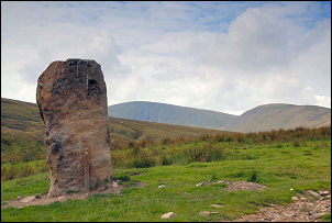
On a clear day this would be a superb vantage point, but not today. I descended to the NW towards the Adamthwaite access road. Just before reaching it I came across a fenced off automated weather station, or more accurately a rain gauge. After crossing the road I took a direct and steep route up Knott and over to the NW to pick up the old track marked on the map. I could see it winding its way towards Long Gill and Green Bell. I didn’t follow it all the way but turned to the left to the saddle between Grere Fell and Adamthwaite Bank. There is nice old drove road here and I followed it part way before descending a gulley towards Adamthwaite. By the path was a large stone monolith which doesn’t appear on the map. A closer inspection showed a lot of digger bucket scars on it which indicated it was probably erected fairly recently, maybe when the adjacent new-ish barn was constructed. |
|
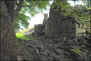
I descended to Adamthwaite Farm and followed a very muddy farm track along the east side of Wandale Hill. The track soon improved and was a pleasure to walk along. The views of Wandale Beck were impressive and then the wide valley of the Rawthey came into view. After passing some ruined barns I came to the sad ruin of the farmstead of Wandale. These substantial buildings used to be the home for 12 people according to the 1851 census. |
|
|
|
Further on the farmtrack became impassable as water erosion had cut a deep rut down the middle. Walkers have to divert into the field adjacent and a new path is starting to form. At Narthwaite I walked through the farmyard where a man was doing some building maintenance and followed the farm’s access road down to Handley’s Bridge and over the River Rawthey. A short walk along the A683 took me back to the car. |