|
Scales Fell, Blencathra, Cloven Stone, Mungrisdale Common, Cumbria. Wed 02 Aug 2006 |
|
|
A bad weather forecast turned out to be correct. The wind and cloud increased as I got nearer to Cumbria and by the time I arrived at the foot of Blencathra the rain had started. I set off up Mousthwaite Comb and followed the main path for a while. Then I turned left to climb steeply up towards Scales Fell. Before long I was in cloud and just plodded on following the old ziz zag track. The rain eased but the wind increased and the temperature started to drop. With little visibility I couldn’t judge how long I’d be on the ascent but when I came to the straight sections of re-made track I knew I wasn’t far from the top. I reached the branch to Foule Crag, which is where I was heading, but carried on to the summit at Hallsfell Crag for a quick look. There was nothing to see so I retraced my steps to the path branch and followed it towards the top of Sharp Edge. |
|
|
|
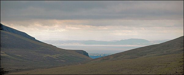
I found some shelter and had a short sit down to have a coffee break. There was still no visibility so I headed off on a compass bearing over Foule Crag then steeply down the scree on the west side. Before long the outline of Mungrisdale Common appeared to my right and Roughten Gill below. I was heading towards the Clove Stone which was over the brow to the NW and still out of sight. By now I had some nice views towards Keswick and also between Skiddaw and Great Calva I could see across the Solway Firth to the Scottish coast 50km away. I continued to follow a compass bearing towards the Cloven Stone and then, just as I walked over the brow of the hill, there it was just in from of me. Approaching from the south it’s easy to see where it got its name; it looks a bit like an oversized cloven hoof. I’d thought of having my lunch here but could find no shelter from the cold north wind. |
|
|
|
|
I followed the faint path to the cairn to the NE and decided to lunch there no matter what. As expected there was still no shelter but I decided to use my one-man Vango storm shelter. It’s been sat unused at the bottom of my rucksack for ages so I was glad to give it an airing. It’s a ventilated bag with a viewing window that goes over the whole walker and equipment. It certainly did the trick and I was able to eat my sandwiches and drink my flask of coffee in total comfort while the wind and rain battered the outside. The warming orange glow inside lulled me into a false sense of security. When it was time to pack up and continue it was back to the cold misery of outside. I splashed my way over Mungrisdale Common through very heavy downpours. I descended into the valley of Blackhazel Beck to try and find the path shown on the map; there wasn’t one. So I squelched across the beck and up to the right and the Hause between Bannerdale Crags and Sharp Edge. Now I was on familiar ground and a path at last. I descended the Glendaramackin to the footbridge. The weather had cleared a bit and some patches of sun came out, but the Blencathra summit was still in cloud. A short climb took me to the top of Mousthwaite Comb where I could see the descending path and my car far below. |
|