|
Dockray, Watson's Dodd, Helvellyn (inc. summer solstice), Fairfield, Cumbria. Mon 19 Jun - Fri 23 Jun 2006 |
|
|
Mon 19 June 2006 Back-pack Cumbria. Vango TBS Minor 100 tent. |
|
|
The fare was £3.50 to Aira Force, or Park Brow Foot as the ticket calls it. This seemed odd as I can't see that name on the map. The first part of the bus ride seemed to be all round the town and it was ages before we headed off into the countryside via Eamont Bridge and Stockbridge. It was cloudy, misty and raining with not much to see. I arrived at Aira Force and my first job was to put all my waterproofs on. The rain was quite light and drizzly but I still didn't fancy walking in it. I kept to the road and firstly climbed to Dockray and fortunately the rain stopped and I was able to dispense with claggy waterproofs. Turning left in the village I had the long steep drag up to Red Moss car park and then left to Dowthwaitehead. The road ends here but the path continued up the right side of Rush Gill. 'No Path' signs abound and no guidance is given on how we're supposed to find the permissive path. I got there eventually. An old green track runs easily up the deep valley side and emerges onto Dowthwaitehead Moss which is well named as the area is wet, boggy and not nice walking. I headed for Randerside Fold and the contour towards Lurge Crag. I was heading for a high plateau of ground so followed a stream up to just below the col. I decided to pitch below the summit as there was some shelter from the wind and none on the summit. A previous visit had revealed a nice clear spring ahead which I used to collect water then back to the tent to shelter from the drizzle and continuing mist. |
|
|
|
|
|
|
|
|
|
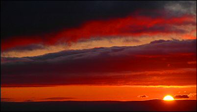
It came and went with no sign of the sun, though a shade of pink could be seen in the distance. I'd made the mistake of leaving my gloves in the tent and wished I hadn't. The wind and cold soon had me pushing my hands as far as I could into my pockets. I walked over to the four sided shelter and noticed a solo walker there who'd also come to see the sunrise. He'd just walked up from Glenridding and had set off at 2am. He’d expected to see head torches bobbing around the fells as others repeated his attempt. He was the only one. Perhaps the weather put everyone off? I took some shelter and noticed the view improving. Not a clear sun but very nice pink rays causing a distant sunburst. So it was worthwhile after all. I said my goodbyes and headed off back to the trig point then back to the tent for a much need brew of tea and some breakfast. |
|
The weather forecast was for the wind to increase later in the day. My tent was pitched in the open and I didn't know what windspeeds would come. The radio said 60mph for Cumbria and at my altitude I don't know what that would be so I decided to relocate. I took my time as I wasn't going far. I packed up and set off at 9:15am heading SE towards the main track off Helvellyn. |
|
|
|
The going was then very easy and I followed it over Nethermost Pike to Dollywaggon Pike. Here was a sheltered spot behind some rocks that I'd used before. It's the only shelter I know of for miles and I wanted to stay high in case of a chance of seeing a nice sunset. So here I camped. Later in the afternoon I went for a wander and recorded a windspeed of 27knots. It was still relatively clear with no sign of the heavy rain that had been forecast. |
|
Thu 22 June 2006 Another wet and windy night but not as bad as expected. With only a half day's walk ahead I didn't set off till 8:35am. Well, it's the 22 June and I should be walking in nice warm summer sunshine. The fact is I'm virtually kitted out in full winter gear including mitts. Where's all this global warming I keep hearing about? It's still windy but nothing like the weathermen's predictions. I reckon some gusts were up to 30knots but I've been in a lot worse. The rain continued but it wasn't heavy, but the main problem was walking in thick cloud. Not because I couldn't find the way, I was on a path resembling the M6, but because with no view it can get monotonous. The start of the descent of Dollywaggon Pike was helped considerably by the wonderful work done by the Pathfairies, that magnificent group of men (I've never seen any women doing it) who build the paths from huge blocks of stone that have mostly been flown in by helicopter. Near the bottom of the descent the choppy surface of Grisedale Tarn appeared out of the mist. I crossed the stepping stones and up the path, which was now a river, up to Grisedale Hause. A left turn and I was on the steep, steady trudge up to Fairfield. The time didn't seem to register as I climbed up through the mist. The summit was reached, which I had entirely to myself, and then following a compass bearing I started the descent towards Great Rigg. Just over it's summit I came to the fork in the path that indicates the branch directly down to Grasmere. |
|
| I pressed on towards Heron Pike and thankfully a bit of a view. Now I could see where I was going I could judge at what point to strike off for my planned pitch near Alcock Tarn. The rain wasn't as bad but the wind was still up. At the saddle before Heron Pike I turned right and headed down to the left of Rowantree Gill towards Butter Crag. In this collection of rocky outcrops I found a reasonably sheltered spot to pitch the tent. The rain continued for the rest of the day but stopped around 6pm as the clouds also began to thin. |
|
|
Fri 23 June 2006
|
|