|
Wasdale Head, Lingmell Gill, Mickledore, Broad Stand, Sca Fell, Cumbria. Wed 14 June 2006 |
|
|
My drive to Wasdale was under a beautiful blue sky, but things had started to haze over as I arrived. The drive over Birker Fell wasn’t helped by being stuck behind one of those brain-dead drivers who are oblivious to a string of traffic stuck behind them who have a life and want to travel at more that 20mph. I was stuck behind one for over 15miles! I’d like to say whinge over, but I got another one on the drive back. About 8:15 arrived at Wasdale and parked in the lay-bye just north of the lake. I would have gladly parked in the official car park nearby but £4 to leave my car in a wood with no security is just greed of the Council, whinge 2 over. My objective was Sca Fell via Broad Stand. It’s a route I’d done a couple of times before with no remembered difficulty but in recent years I’d been reading horror stories about it and A. Wainwright’s book didn’t help. |
|
|
It was warm with hazy sun as I set off along the track by the car park and camp site. I followed the main path up Lingmell Gill and Brown Tongue to where the path splits. The left branch goes to Lingmell Col and the easy way up Scafell Pike and the right up to Mickledore. I headed right and plodded on up the easy but deteriorating path. |
|
|
|
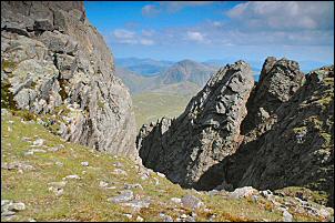
To my right I could see a sign planted in the path up to Lord’s Rake, presumably saying ‘path closed’. The route is now unstable because of constant rockfalls. My climb up to Mickledore was the usual loose rocky scramble but at least the weather is fine. The last time I was here was with Eric. It was thick mist and raining and very uncomfortable. On the top of the col I stopped briefly to take in the views before turning right to the vertical rock face that seems to block the way to Sca Fell. |
|
The ‘way’ is the narrow gap of ‘fat man’s agony’ which I found a bit difficult due to having my rucksack, camera bag and tripod to drag through. I was then on a rock shelf. Wainwright’s Southern Fells book refers to this point as notorious and not for walkers. The way on is a short traverse to the left and up to another platform which is smaller and a bit more sloping. One advantage of keeping a diary is being able to refer back to previous visits. My first to this point was Mon 4 May 1981 with my brother. We didn’t climb the crag then because of snow. The second was Sunday 30 Aug 1981. I was with Charlie doing a 1.5 day backpack to reconnoitre the Lakeland 3000s peak route. Charlie thought we were going to climb Sca Fell via Lord’s Rake and seemed a bit surprised when I lead him up to Broad Stand. I found the climb quite easy but Charlie needed a bit of a pull up. The third visit was in the early hours of Sat 25th June 1983. I was with Charlie doing the Lakeland 3000s in one go. It was a repeat of the Aug 81 route and this time we both managed the climb without assistance. The scary thing is how long ago all this was, over quarter of a century since my first visit! |
|
|
Back to today. Previously we’d come back the same way so left our packs at the bottom. Now I was on a one way walk so had to get my pack up the climb. The pitch is about 2.5m, too high to push my bags up. I had a length of thin nylon line in my pack so tied it to my pack and camera bag with my tripod stuffed in the side of the rucksack. I tied the other end to my right boot ankle. Once again I found the short pitch quite easy but as I stood on the top I realised that the string was too fine to hold in my hands without slicing my fingers off! So I wrapped it round a hand sized rock and slowly reeled in my gear. Once up the rest of the route to Sca Fell was an easy series of slopes and flatish bits. |
|
|
|
I could see across to Scafell Pike with many people on its summit, the highest mountain in England. I was on Sca Fell, the second highest mountain and I was on my own. I continued south for a while and turned towards Burnmoor tarn to start my descent down the SW slope. |
|
|
|
| Once the gradient had eased I traversed round to Groove Gill passing over grassy but sometimes quite boggy ground. Eventually I reached the old Corpse Road and followed it down and back to the car. | |