|
Kirkstone Cove to Dollywaggon Pike and Dunmail Raise, Cumbria. Tue 23 May - Fri 26 May 2006 |
|
|
|
Tue 23 May 2006
|
|
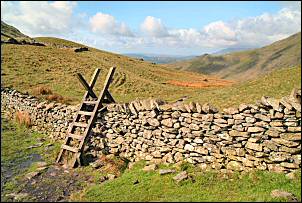
I took it steady as most off my planned walk today is on the road. The views were nice and after the first uphill haul the gradient eased for a while. Up to my left the stone quarry was working away and several cracks echoed as explosives were used to loosen the rocks. The final part of the climb is called 'the Struggle' on the map, but I think it was steeper lower down. At the Kirkstone Pass Inn I stopped a while and looked at the front door. A date of 1496 was painter over the entrance, which would be quite impressive if it were true, I hope it is. I kept to the road for a short way then climbed over a section of collapsed wall and joined a faint path which took me to the Kirkstone. |
|
|
|
A little way below was a small car park which I passed and took a diagonal line up the fell to the left, heading up to Kirkstone Cove. The only naming of the cove I can find is on the 1862 Ordnance Survey map, but it’s been dropped from following editions, I wonder why? With no path I had to find the best way I could. I soon came to the wall that runs directly up to the cove and kept it to my right as I followed a zig zag way up. The base of the cove is far from level so I headed up towards Red Screes summit, making sure I didn't get too high. I found a nice flat area for my tent and managed to get it pitched just as the rain started. Some cloud rolled in during the afternoon but the rain was only light. However, during the evening and night it rained hard and the mist thickened to pea-soup consistency. At least it wasn't too windy. |
|
Wed 24 May 2006
|
|
|
|
There were a few patches of sunshine in the distance but none where I was. It was quite cold in the wind, the temp hovering around 5deg C. I took my time on the climb up to High Bakestones and the large cairn. It came in handy as a wind break as I sat down to take in more views. The wind became quite strong over Dove Crag and I was glad to be descending into Houndshope Cove to get out of it. |
|
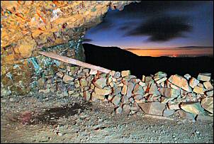
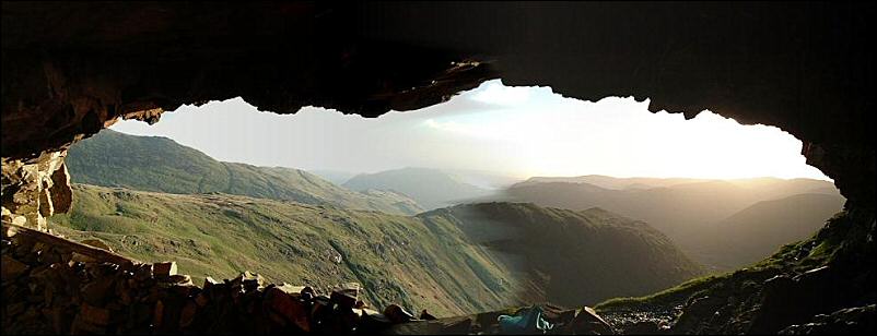
My plan was to spend the night in Priest's Hole cave. The last two times I tried I couldn't get to it because of snow and ice, but now I had no such obstacles. The climb up was relatively easy and I had the cave to myself. It was interesting reading the log book which is safely housed in a metal box along with bits and pieces left by previous occupants. Some half consumed bottles of spirits were there including some Southern Comfort, but I left them alone. The views from the cave were impressive; I could even see the radar dome on Great Dun Fell. |
|
|
|
|
|
|
Thu 25 May 2006
|
|
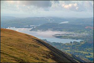
We arrived at the summit at the same time. He'd just walked up from Ambleside and said it was misty low down when he started. There was a nice view down to Windermere and some mist was still hanging around above the surface. |
|
|
|
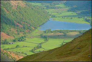
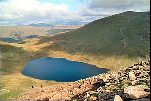
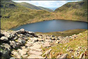
I continued to Fairfield and started the steep descent to Grisedale Hause. The lone walker was no longer around and must have descended via Heron Pike. Two fell runners came up as I was descending. They must have just gone to the Fairfield summit and returned as they soon overtook me on the way down. Before I got to the bottom they'd climbed Seat Sandal on the other side. Grisedale Tarn was quite choppy in the wind and didn't have the photogenic qualities it had the last time I was here. |
|
The climb up Dollywaggon Pike was steady and straightforward. Over half way up I came across a couple of men working on the path construction. Quite a bit had already been done below where they were working. I thanked them for their work but they were uncommunicative so I pressed on. |
|
|
|
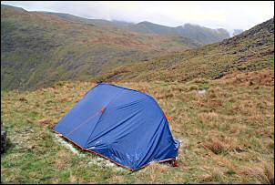
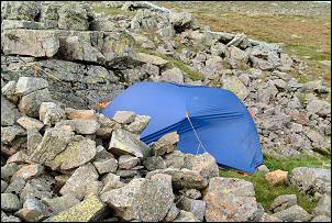
It was still sunny in patches with a bit of wind. I pondered where to pitch as I needed somewhere within striking distance of a bus stop. On the west side of Dollywaggon Pike I came to a previous pitch I used with good shelter behind a large rock. It was still early but I pitched here as the weather forecast for later wasn't good and other distant pitch possibilities were all quite exposed. |
|
Fri 26 May 2006 The night was wet but calm. By morning a little drizzle was about and some mist. I packed up a very soggy tent and started my descent of the fell at 7:10am. Instead of returning to the path I thought a direct descent to Raise Beck would be more interesting. Another interesting thing I noticed was the spelling of Dollywaggon Pike on the Ordnance Survey maps. The modern 1:25K and the 1862 6in/1mile show it as Dollywaggon, but the modern 1:50K shows it as Dollywagon. The mapmakers deciding to save a letter g. |
|
|
I dawdled down quite slowly as I had plenty of time for the Bus at Dunmail Raise. When I reached the beck I joined the path and as I descended could eventually see the traffic on the road below. I arrived at the bus stop in plenty of time and noticed the Dunmail Raise Hut nearby was occupied by quite a large party, judging by the vans outside. It is run by the Achille Ratti Climbing Club but I’m not sure if they welcome guests so I stayed away. The rain increased again and by the time the bus arrived I must have looked quite a bedraggled site. I arrived at Windermere Railway station with a few minutes to spare before the train took me back to Chorley. |
|