|
Kirkland, Cross Fell, Greg's Hut, Cumbria. Wed 10 May 2006 |
|
|
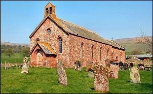
The sky was blue and clear as I approached Kirkland, a few miles to the east of Penrith. Ahead I could see the clear profile of Cross Fell, my main objective of the day. I left my car outside the Church of St Lawrence and leaded off up the track to the NE. it was tarmac for a while and became an un-surfaced road by a small car park. The track climbed steadily up through various areas of old mine or quarry workings. |
|
|
|
This is the second time I’ve climbed this track but the first time I’ve been able to see anything. In mist it gets confusing at one point where the track turns north and the faint path continues straight on. There is no way marker to show the point but anyone with a compass should be able to keep in the right direction. The map shows a bothy off to the right. It was lost in the mist on my last visit but this time I could see it and decided to investigate. It was nothing more than a collapsing corrugated iron shed built inside a stone sheepfold. I stopped for a quick coffee in the sunshine before continuing up the fell. |
|
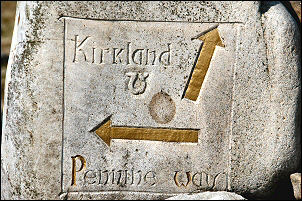
A little over the summit a nice stone way marker shows the branch of to Cross Fell. In mist this would be very useful as even in clear weather the way up is far from obvious. Some of the mini-corries up ahead still had substantial amounts of snow in them. The first part of the way up is wide and wet. Lots of winding detours were needed to keep my feet dry. Just below the summit plateau the map shows a spring called Cross Fell well. It emerges from under a purpose build retaining wall which must have been built a long time ago. |
|
|
|
A few more steps and I was on the final easy walk to the summit shelter and trig point. The views were very good and the radar station on Great Dun Fell had the appearance of a rising full moon as it appeared behind the Cross Fell trig point. |
|
|
|
|
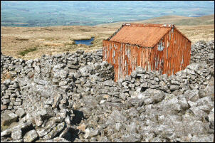
As I descended to Tees Head I met a couple of walkers coming up, they looked like Pennine Way walkers as they were carrying larger than day rucksacks. I then headed NE along a faint path that took me to an area of old mine workings, spoil heaps, ruined buildings and an adit entrance. The track was now quite substantial and I followed it round Rake End till it met up with the Pennine Way, which was a similar track. It was quite stony as I climbed up through a series of old mine workings and a wonderfully named area called Black Gut. The couple I’d met on Cross Fell appeared again on their way along the Pennine Way. As the gradient eased I rounded a bend to see Greg’s Hut in the distance. |
|
|
|
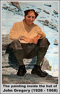
I’d not got this far the last time I was in the area so was looking forward to checking the hut out. I was not disappointed, and had the place to myself as I explored the interior of flagged floors and separate sleeping room. On the wall was large painting of John Gregory (1928 – 1968) to whom the hut is dedicated. The whole place is a credit to the unsung heroes who maintain the building. It was the perfect pace to linger a while and eat my lunch while pondering the surroundings and wonderful views. |
|
John Gregory (1928 -
1968) A welcome shelter from
mountain weather.
|
|
|
|
|
|
|
|