|
Swarth Fell, Wild Boar Fell, Yorkshire + Cumbria. Wed 04 Jan 2006 |
|
|
Left the car at Fell End, NE of Sedbergh, and walked along the narrow road towards Uldale House. It was just coming light as I set off and I had to be careful, as there were several patches of ice covering the road. In the valley bottom was a small hamlet called Needle House and ahead I soon arrived at Uldale House. It was difficult to see the date stone over the front door as it had been painted over in black, but appeared to show 1828. |
|
|
|
|
|
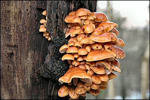
Two views of fungi near Uldale House. 1st with flash then available light. |
|
| A track headed up Rawthey Gill until Whin Stone Gill bridge then soon petered out. A path is shown on the map but any sign of it soon vanished. My first objective was Swarth Fell so I took a diagonal line up the fell side towards the stone wall on Holmes Moss Hill. By now the sun was rising and hitting the Howgills to the west. | |
|
|
|
|
|
The sky above was clear but I was still in shade, as the sun hadn't risen above East Baugh Fell yet. The map showed a point called Joseph's House way up the fell. It hardly seemed likely that it would have been a house being in such a remote area. Nevertheless I decided to investigate. There it was in the distance and when I approached I found a ruin that was still head height and had remains if a door and windows. So it probably was a house in times past. The Ordnance Survey map of 1853 shows it as a ruin. |
| I continued up the lumpy fell side and rejoined the wall. The terrain then changed to stony outcrops, which made much easier going than the difficult ground I'd been on. At Swarth Fell Pike I looked down into Garsdale then took the very nice high-level path to the NW and on to the summit of Swarth Fell. I was lucky as the views were still clear and I could see Wild Boar Fell ahead. |
|
|
|
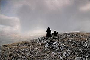
As I descended to the saddle and Tarn at Standard Brow the views vanished into cloud, but the sunny summits of the Howgills could still be seen. A nice path took me along the east side of the summit of Wild Boar Fell but I couldn't see anything. When I arrived at the northern ridge the views opened up and I had a magnificent view down into Mallerstang and the steep rock eastern face of the fell. As I approached the O.S. trig point I saw 2 people and a dog walking in the opposite direction and in to the mist. |
|
|
|
| A steep and pathless descent took me down to Sand Tarn which had a fairly low water level considering the rain we'd had over recent weeks. As soon as I found a little shelter I stopped for some lunch before continuing my descent through old quarry or mine workings and on down to the road at Ash Pot. A short walk took me back to the car. |
|